The real fake islands where people fake bike
When people want to practice at biking but don't actually want to bike, they use a special kind of exercise bike called a "bike trainer". For over a century, people have used trainers or rollers to practice riding on their actual race bikes during the winter, or in bad weather, when being outside is not comfortable.
Modern trainers are usually electronic devices which can track your cycling power statistics - the amount of effort you're putting out, your consistency, and so on. They may also pair with a heart rate monitor for even more complex stats about your exercise. You buy a device like this as either as a full exercise bike, or as a device which replaces the rear wheel of your actual bicycle.
Over the course of the last decade, a company called Zwift has begun turning modern electronic bike training into a videogame. Zwift hooks up to your trainer and reads its data to depict you as if you were in a real bike race against other people, also biking at home on their bike trainer. You stick a laptop or an ipad or whatever in front of your trainer and watch yourself keeping pace against a peloton of other Zwift users, racing around a fantastical environment.
You can then upload that course to Strava, an exercise tracking/social media app popular amongst cyclists. Strava allows you to follow a list of people - friends and pro athletes both - and see all their exercise activities, including maps of their routes if they were running, walking, or cycling. When Zwift launched, however, you could only upload a map component for your exercise if you were cycling in the real world.
That is no longer the case. Zwift partnered with Strava at some point to establish a standard for depicting "virtual rides" as routes in the real world. In its post in your activity feed, the shape of the course in Zwift is painted into real world at a particular spot, and voila, these Zwift rides you did on your trainer in your basement start to look a lot more like the real-world rides your friends are posting.
...Until you look more closely. Zwift rides are sometimes depicted in the place of a real-world bike path or race route; if they're based on a real place, the map backdrop in the "virtual ride" Strava activity will show that map location. Most of the time, however, these rides are depicted against the backdrop of one of several small islands. The course will veer off the topography of the island, disregarding its slopes and zooming over the ocean. The people who design courses in Zwift are not actually trying to design realistic routes on these islands' topographies. They're designing routes which are fun in the game, and just projecting them on top of the islands in order to assign them a location for the map stuff in Strava.
According to this community site tracking Zwift game info, here's what the map looks like in-game:
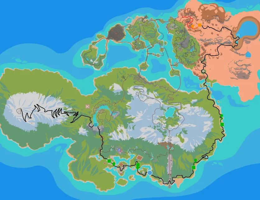
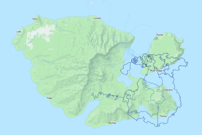
In the game, these Zwift rides take place in a fantastical land called "Watopia," after the unit - watts - cyclists use to measure their power output. But the islands are real. There are towns named on these maps in the Strava preview. You can click on a Zwift "virtual ride" map and zoom out until you find the rest of the world.
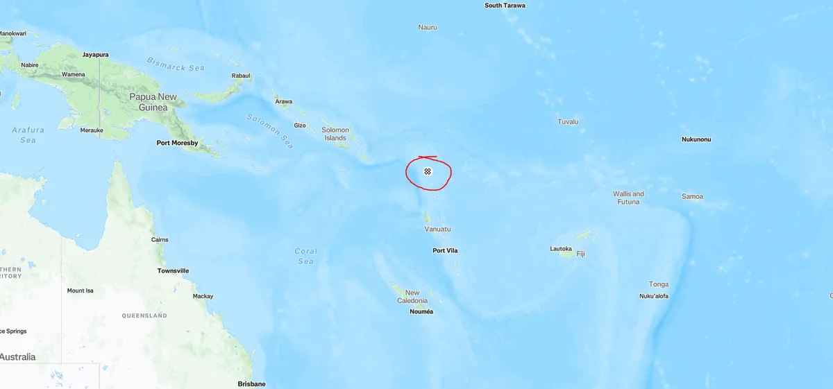
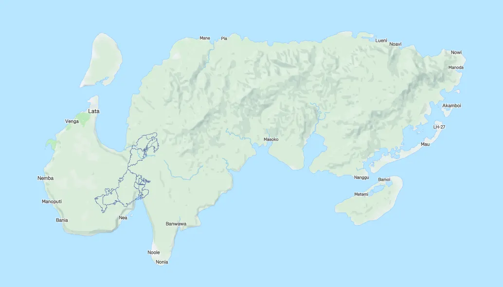
"Watopia" is actually some of the islands in the Solomon Islands. The islands I frequently see it use are Banie and Nendö. These are real places where real people live. Not a lot of people - but they're real, and they live there.
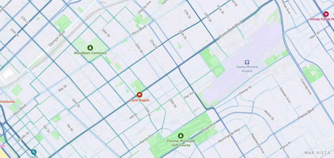
Nevertheless, these islands are painted with the "heatmaps" of riders from the Zwift app. Strava tracks the roads its users are choosing the walk and bike on, and makes that data available to anyone. This has, in the past, revealed military secrets. Here's a heatmap for part of Santa Monica:
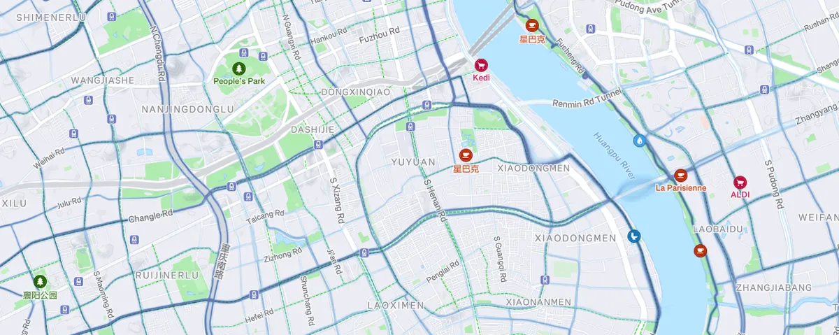
Here's a heatmap from downtown Shanghai:
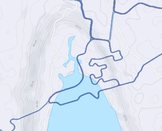
And here's the heatmaps for Banie and Nendö:
You can tell that some of the lines on these island heatmaps are not based on real-world biking because they cross over the ocean in places where no bridges exist. However, Strava doesn't make it clear that the routes are fake. Some route-sharing websites actually contain routes in this area uploaded by users, and although I am pretty sure that these are impossible Watopia routes, Zwift and Strava don't clearly designate this heatmap data as "virtual".
Furthermore, I'm not 100% sure that Zwift automatically paints the routes onto Strava - It's possible that the heatmaps on Strava might be thanks to users uploading this data themselves outside the Zwift tools. I can't check, because I've never used Zwift. (I have no reason to use it in a city where it never snows and rarely rains.) But even if Strava and Zwift did not decide together to put "virtual ride" heatmaps onto the real topography of a real place, they still created a situation where riders might choose to upload these routes to this location and do their weird heatmap graffiti themselves.
It's really strange, isn't it? Real people live here! There aren't a ton of people living on THESE islands, but they're still real people, and the bike heatmaps depicted here are not actually real bike routes that any of these real people are biking on. In every other country on earth, the point of the Strava heatmap is to show you were real people are actually biking.
The Zwift fan wiki contains some phrasing about Watopia that feels like reflected marketing copy, to me - but also don't feel even remotely accurate. These routes are not "loosely based on a pair of islands in the Pacific Ocean." They are simply something completely different.
According to a random poster on Reddit, Watopia was originally located on Jarvis Island before moving to the Solomon Islands. Zwift chose these locations because there were no Strava "segments" in any of these places. Strava segments are regions of road which track athlete performance and carry a leaderboard. There are hills in my town, for example, which are Strava segments. What would happen if someone created a Strava segment on one of these two islands? Would these massive exercise companies be suddenly forced to summon the engineers, throw a bunch of tasks onto the next sprint, and move Watopia somewhere else?
Would Strava simply prevent anyone on these islands from establishing a Strava segment?
This is fascinating and weird and absolutely something that could provide a kickoff for some long-form journalism, IMO. I've got a lot more questions which could only be answered by someone with the time to learn about bike culture on the Solomon Islands. How familiar are the people who live on these islands with the fact that a pair of massive exercise apps have decided together to pretend that all the sweaty basement bikers of the world are biking ghostly above their heads all day long? Why did Zwift move away from Jarvis Island, and when they moved, why did they and Strava choose to put their rides on these real islands rather than over, say, the ocean? Or on a separate Strava map of the imaginary land of Watopia? What is bike culture like in this country generally? Did Zwift pick this place because they hoped that these places were so impoverished and remote that no locals would ever use Strava? What if a local did use Strava? All you need in order to use Strava is a device with GPS tracking, and the desire to walk. Doesn't it kind of defeat the point of Strava to let or encourage or even create a situation where Zwift users might graffiti these islands with their trainer routes?
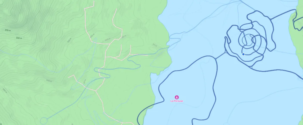
I'm sure that none of the lines in the screenshot above are from real life. if they were, there would surely be at least some ghostly lines following the real roads in this screenshot.
If you zoom in close enough, you can see even fainter lines which may be older or less-used Zwift routes. They don't follow the roads. They don't make much sense. They don't represent anything from the real world or anyone living here.
The reason all of this happened in the first place can probably be easily explained by the fact that "virtual rides in Strava" is the product of two tech companies collaborating in a business partnership. Both Strava and Zwift benefit from it - Strava gets more engagement from users during the winter months, when they're stuck on their trainers, while Zwift gets free advertising in the form of more-attractive and eye-catching "virtual ride" maps in the Strava activity feed. I'd be really surprised if either company considered it a priority to get these rides off of the Solomon Islands, or to create a separate 'Watopia only' map for displaying Zwift rides in their in-game context. That probably adds a ton of asset production responsibilities for both companies, and and probably would require both of them to tackle a lot of tech debt.
But still... it's fucking weird that THIS is the solution they picked instead! The empty ocean is right fucking there!!