A map of where my favorite campsite burned down
Earlier this year, the Bridge Fire in the San Gabriel mountain range nearly swallowed the town of Wrightwood. Wrightwood was mostly saved, but a huge area south and west of the town burned.
Just northwest of Wrightwood is Table Mountain Campground, the campground I've been visiting in the LA area for longest. It offers amazing views of the surrounding mountains, Palmdale and the desert to the north, and the ski slopes of Mountain High to the south and west. It's the kind of place I'd go at least once a year to sit around at massive elevations and drink beer and listen to my friends play the guitar. And, unfortunately, the fire wiped it out. The burn area swallowed the campground, then ended as it hit the more deserty area to the northwest.
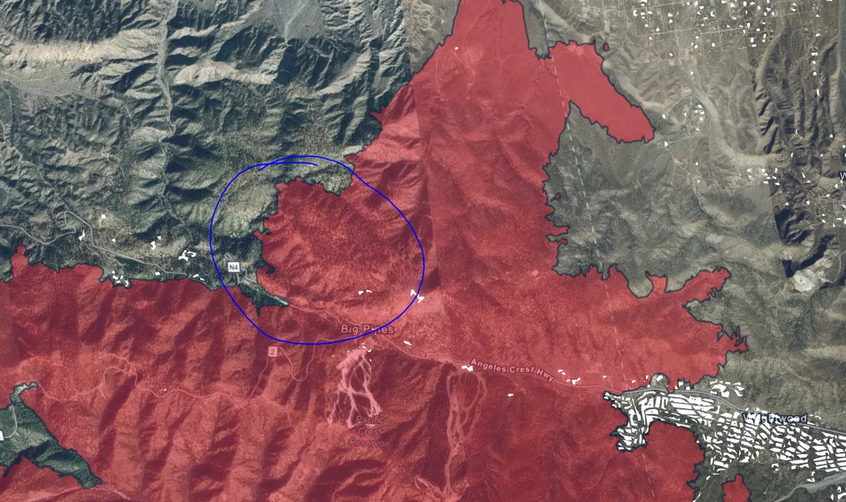
You can see the California Department of Forestry's map of the burn area here. Table Mountain Campground is located at the far north of the burn area. Here's a Google maps link to the campground so you can compare it with this map.
While the fire was happening, I kept checking various state agencies' live fire maps, watching the fire approach the campground and the town from the south. It's still unclear to me how much of the area actually burned down, since the facilities at Mountain High were actually saved by the resort's snow machines. But there aren't any snow machines at the campground, so it's probably (quite literally) toast.
I have no idea when or if I'll ever be able to go back there, which is really weird. Fires in this area leave behind a lot of different "fire follower" plants which grow in the burn areas as part of the regrowth process, some of which, like poodle dog bush, are pretty hazardous. They won't necessarily make all the burnt places inaccessible, but it's just a new thing to worry about as the place regrows. I've never had a "favorite place" burn down in a southern Californian wildfire before so I have no idea how this stuff will affect the places I used to go. I have seen people who hike in the San Gabriels talking about how there are certain extremely backcountry trails they might not choose to visit for years because they'll be covered in PDB.
That said... there is a region northwest of Table Mountain Campground that I drive through every year while coming to the campground. Once you cut south into the San Gabriels from that direction, you pass through a foothills area which burned down a while ago. When I first started visiting the campground, the trees in this area were completely black and roasted. Then there was a period of a couple years where the trees were half roasted, and half green - portions of each tree had survived, and they were putting out new branches. Over the last 2 or so years, these trees have grown out so completely that there are many which have completely shrouded their own burned branches in new, green branches. It was completely crazy to me how quickly those trees along the road in particular reestablished themselves. There are trees I remember well - I have photographs I took of them in previous years, when they looked alien and scary - which are now completely unrecognizable. The gnarled, black, alien shapes are hidden, and they're back to being a whole-ass tree again. It's really incredible.
These are not the same species as the trees around the campground, but it's been very reaffirming over the last 5 or so years to see this burned area bounce back. Fires really are part of the southern Californian forest ecosystem. The fires we humans have forced the landscape to experience are no good - too hot, too huge, not managed correctly, not relying on more ancient, traditional methods of forest management that local native people developed over centuries - but shit can come back from fire. I'm hoping very fervently that my favorite campground will be less of a blasted crater and more of a place that regrows.